Lingque data products and solutions
1.Data products
1.1.optics
Spatial resolution | 0.5m~1000m |
Price | Monolithic archive: 2~200 yuan/km² |
Monolithic programming: 40~1000 yuan/square kilometer | |
Three-dimensional archive: 60~1000 yuan/square kilometer | |
Three-dimensional programming: 60~2300 yuan/square kilometer |
1.2.radar
Band type | C频段、Ku频段、L频段、X频段 |
Imaging mode | Gaze Beam Mode, Beam Mode, Band Mode, Scan Mode, Wide Scan Mode |
resolution | 0.3m-1m、3m-25m,50m-100m,10m-500m等 |
Price | Archive: 13000~ 133400 yuan/scene |
Programming: 20000~168290 yuan/scene |
1.3. Hyperspectral
resolution | 10m、30m、250m、1000m |
Number of bands | 32、36、330 |
Spectral range | 0.4~2.5um |
Price | 10000~75000 yuan/scene |
2.solution
As a satellite company specializing in remote sensing technology, we have the expertise and technical strength to provide customized solutions for a wide range of industries. Whether it is in agriculture, environmental protection, urban planning, resource management, disaster monitoring or other fields, we can provide customers with accurate and efficient data support and analysis services. The business team has multi-domain expertise and extensive project experience, and is able to tailor solutions to help solve existing problems and achieve business goals.
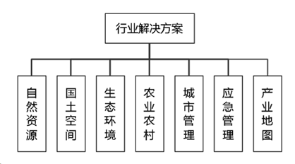
2.1. natural resources
Satellite remote sensing imagery data can be used to monitor and assess the distribution, change and use of natural resources such as land, water and atmosphere. At present, the technology can be used to monitor forest cover change, land use and land cover change, water resource distribution and water quality change, crop growth, natural disaster monitoring and early warning, etc., providing important data support and scientific basis for the rational use and protection of natural resources.
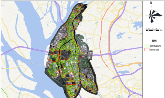
2.2. Territorial space
Satellite remote sensing image data can be used to monitor and evaluate the distribution, utilization and management of national land resources. This technology can be used in land use planning, urban development monitoring, resource investigation and assessment, land change monitoring, environmental protection and ecological restoration, etc., and provides important data support and decision-making basis for the scientific management and sustainable use of land resources.
The company can provide professional status and change monitoring service products such as land cover/utilization, land resources survey, mineral resources survey, ecological geological environment remote sensing survey, etc. Most products have a spatial resolution of better than 1 meter, and the monitoring period varies from weekly to quarterly.
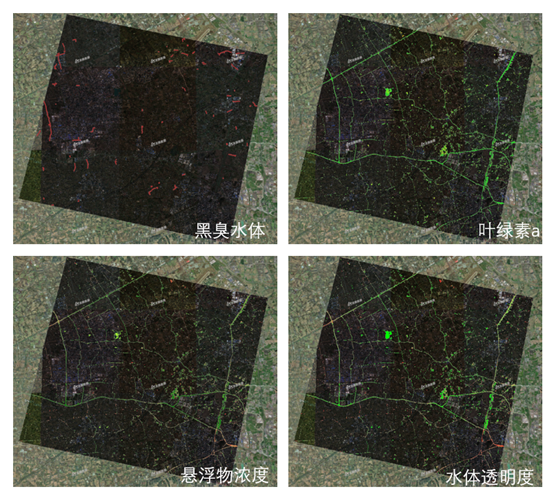
2.3. Ecological environment
Satellite remote sensing image data can be used to monitor and assess the status, changes and influencing factors of the ecological environment. This technology can be used to monitor land cover change, vegetation health, water pollution and water quality change, soil erosion and land degradation, climate change impacts, etc., providing important data support and scientific basis for ecological environmental protection, restoration and management. Through remote sensing technology, environmental problems can be discovered in time, ecological risks can be warned, and relevant departments can be guided to take effective measures to promote the sustainable development and ecological security of the ecological environment.
The company can provide a variety of monitoring service products such as river and reservoir water quality, cyanobacterial blooms in key lakes, marine red tides, suspected oil spills, water eutrophication, land desertification, and ecological restoration. Most of the products have a spatial resolution of better than 1 meter, and the monitoring period varies from weekly to semi-annual.
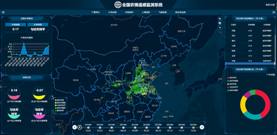
2.4. Agriculture and rural areas
It can monitor and evaluate all aspects of agricultural production to improve agricultural production efficiency, resource utilization efficiency and environmental friendliness. This technology can be used to monitor crop growth, identify pests and diseases, assess soil nutrient status, formulate planting plans and agricultural policies, monitor farmland irrigation, precision fertilization, etc., providing important data support and scientific basis for the precision management of agricultural production and the development of smart agriculture. At the same time, remote sensing technology can also be used in rural planning and development, land use and protection, rural environmental protection and improvement, etc., to promote sustainable rural development and improve farmers’ living standards.
The company can provide a variety of service products such as crop planting distribution, accurate identification and classification of crops, crop growth, remote sensing yield estimation, pests and diseases, facility agriculture survey, agricultural insurance, etc. Most of the products have a spatial resolution of better than 1 meter, and the monitoring period varies from weekly to semi-annual.
The company can provide a variety of service products such as crop planting distribution, accurate crop identification and classification, crop growth, remote sensing yield estimation, pests and diseases, facility agriculture survey, agricultural insurance, etc. The spatial resolution of most products is better than 1 meter, and the monitoring cycle ranges from weekly to every six months.
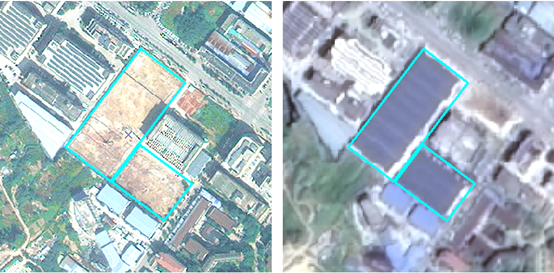
2.5. Urban management
It can be used to monitor and evaluate various urban infrastructure, land use, environmental quality and population distribution. This technology can be used in urban planning and development, land use and management, transportation planning, urban environmental protection and improvement, urban risk management, etc. Through remote sensing technology, urban management departments can obtain information on urban changes in a timely manner, formulate reasonable urban planning and policies, improve the city’s operating efficiency and quality of life, and promote sustainable urban development. At the same time, remote sensing technology can also be used for urban disaster monitoring and emergency response to improve the city’s safety and disaster resilience.
The company can provide a variety of products and services such as construction project progress monitoring, monitoring of large garbage piles, and monitoring of suspected illegal construction.
2.6. Emergency management
Used for disaster monitoring, disaster assessment, post-disaster rescue and reconstruction, etc. Remote sensing technology can provide real-time information on disaster sites, including the scope and extent of natural disasters such as floods, earthquakes, fires, and wind disasters. It can help emergency management departments take timely measures to respond to disasters and guide rescue efforts. In addition, remote sensing technology can also be used to monitor emergencies such as environmental pollution, meteorological disasters, and epidemic spread, providing data support and scientific basis for emergency management. The comprehensive use of remote sensing technology and geographic information systems can improve the response speed and accuracy of emergency management and minimize the losses caused by disasters.
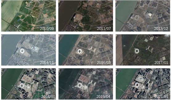
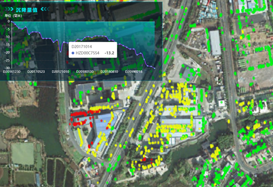
The company can provide a variety of service products such as remote sensing monitoring of forest fires, flood disaster monitoring, three-dimensional real scenes of chemical industry zones, geological disaster monitoring, and subsidence monitoring.
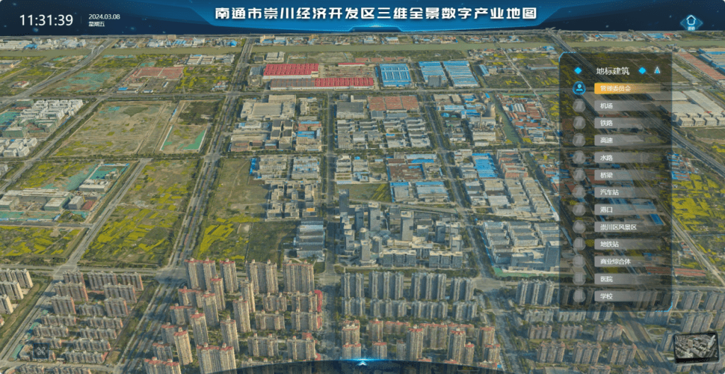
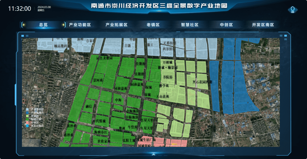
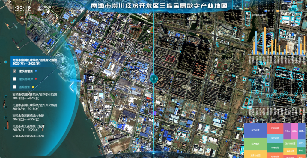
2.7. Industry Map
Based on geographic information system (GIS) technology and data visualization technology, by integrating various digital industry-related data, including enterprise distribution, industrial parks, talent distribution, policy support and other information, this information is displayed visually on the map. Maps can be customized according to customer needs, showing different industry types, regional characteristics, development trends, etc.