Monitoring and evaluating natural resources is to understand their status, changes, and degree of sustainable utilization, in order to effectively manage and protect these resources
Monitoring and assessing natural resources is important for several reasons. First, it allows the health and sustainability of natural ecosystems to be assessed. This information is essential for making informed decisions about how to manage and protect these resources for future generations. In addition, monitoring and assessing natural resources can also help identify areas in need of protection and areas where resources may be overexploited.
How important is application data monitoring resource allocation?
It is important to apply data to monitor resource distribution. It allows for a better understanding of how resources are distributed across different ecosystems, regions and countries. This information is critical to managing resources in a sustainable and equitable way, as it can help identify areas where resources are scarce or overexploited, and where conservation efforts should be prioritized. In addition, data on resource distribution can inform policy decisions and help guide resource management strategies. In general, the application of data to monitor resource allocation is essential to ensure the sustainable use and management of natural resources.
Monitor and evaluate forest cover
Changes in forest cover can be monitored through satellite remote sensing technology. By using time series data from satellite images, trends in forest cover, including deforestation, revegetation, forest fires, etc., can be observed. In addition, the monitoring results of satellite images can be verified by ground surveys and sampling.
Monitor and evaluate the distribution of water resources
Monitoring the distribution of water resources can be done through the use of remote sensing techniques and hydrological monitoring stations. Remote sensing technology can obtain the distribution of water bodies through satellite and aerial remote sensing data, including the distribution of water resources such as lakes, rivers and wetlands. Hydrological monitoring stations can obtain the distribution and change of water resources by monitoring water level, water quality and other indicators.
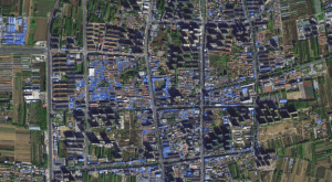
Monitor and evaluate land use rate
Monitoring land use can be done through satellite remote sensing technology and ground surveys. Satellite remote sensing can obtain land use and cover information, including farmland, forest land, grassland, urban construction and so on. Ground surveys can verify the accuracy of satellite remote sensing data through field visits and data collection, and obtain more detailed and accurate land use information.
By comprehensively utilizing these methods and technologies, comprehensive monitoring and evaluation of natural resources can be carried out, providing scientific basis and decision-making support for effective resource management and protection